
By David Harrison
If you were able to go back to the central London of mid-Victorian times, there would be many surprises. Using the recent lockdown to do some research into the period, I found a few.
Perhaps most surprising was the existence of extensive measures to prevent rat-running. Our ancestors knew that if we were to enjoy our streets they were best kept free of through traffic.
An early example was in Queen Anne’s Gate built soon after 1700. Next to the blank facade of No 15 is a statue of Queen Anne. On this spot a wall crossed the street preventing carriages and carts from using the road to bypass Tothill St, then the main road west from Westminster (Victoria St was built in 1850 to provide speedier access to the new station).
While major streets in the City of London and East End were crowded with people and traffic, elsewhere new developments were built with barriers and gates. In 1879 it was estimated that there were 150 in London.
They were particularly common in the parish of St Pancras where there were 29 in 1866, including at Oakley and Harrington Squares, now part of grim gyratories just south of Camden Town. Residents on the Bedford Estate were protected by five key lodges and gates—in Upper Woburn Place, Endsleigh Street, Georgiana Street (later Taviton Street), Gordon Street (originally William Street), and Torrington Place.
A heyday of walking
Records also show that the first half of the 19th century was a heyday of walking. Dickens is famous for his long walks and fast walking. He estimated his pace at 4mph. In 1854 he wrote the following to a friend ‘if I couldn’t walk fast and far, I should just explode and perish’.
Around 50 years earlier, architect John Soane often left his London home in Lincoln’s Inn Fields at dawn to walk to Pitzhanger in Ealing for breakfast and a spot of fishing with his friend JMW Turner. That was almost a three-hour walk for most of us, 2 hours 15 minutes at Dickens’ speed!
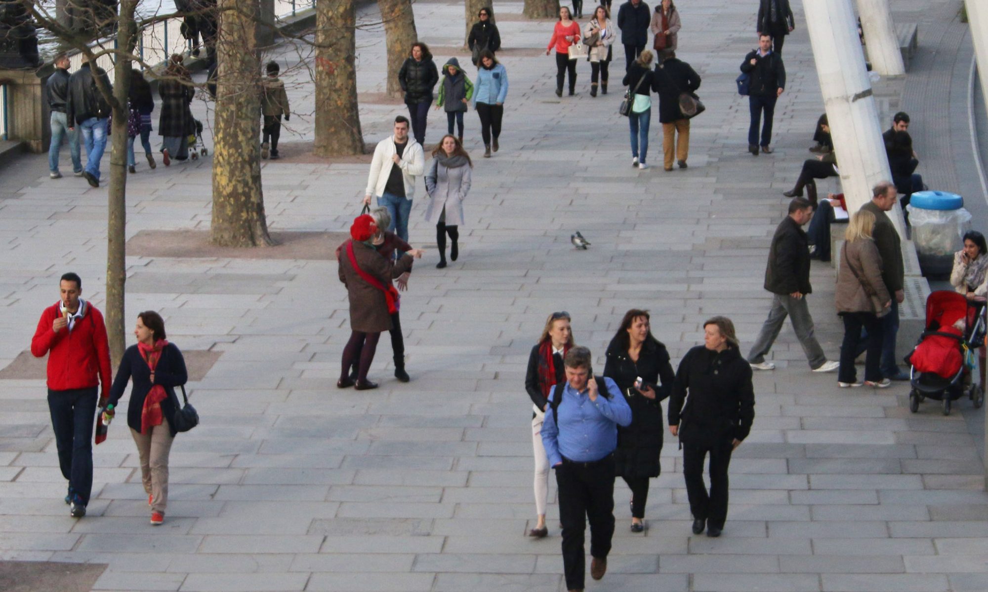
Of course, not everyone walked this far but an enormous number of people did walk to work. Figures are very hard to find, and even specialist transport books rarely have a reference to walking in the index (they are much more interested in developments in public transport).
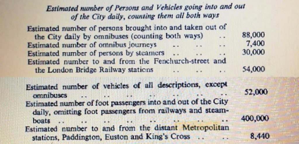
One exceptional nugget of information comes from the catchily entitled ‘Report of the Select Committee on Metropolitan Communications, 1854-5. The evidence given to the Committee provided the following astonishing statistics, including the remarkable fact that 400,000 people walked into the City of London every day.
The 400,000 who walked far exceeded every other means of travelling into the City. This was after the arrival of trains, though before the Underground.
Making sure the traffic flows
However, from the second half of the 19th century conditions changed. Seeking to increase the speed of traffic and demolish the housing of the poor, the Metropolitan Board of Works smashed through new roads, demolishing many historic buildings.
The roads included Faringdon Road (1840s to 60s), New Oxford Street (1847), Northumberland Avenue (1876), Clerkenwell Road (1878), Charing Cross Road/Shaftesbury Avenue(1887) and Rosebery Avenue (1892). The culmination came in the early 20th century with the greatest destruction of all. In the construction of Kingsway and the Aldwych, several ancient streets were demolished as well as 600 properties and thousands lost their homes. About all that has survived from this historic quarter is the Old Curiosity Shop in Portugal Street.
The end of the Low Traffic Neighbourhood
Despite the creation of so many new roads, the determined improvers of late Victorian London were not content. The barriers had to come down too. The Metropolitan Board of Works led the agitation against them. The Metropolitan Cab Proprietors’ United Association complained about the great ‘inconvenience and annoyance’. The Prime Minister, the Marquis of Salisbury, was outraged that the gates slowed down his journey to King s Cross.
The end of peaceful residential streets came soon after. Two Acts of Parliament in 1890 and 1893 authorised the newly formed London City Council to remove the barriers and gates. The residential calm, particularly of Bloomsbury, was destroyed.
The 20th century car city
The scene was set for what was in effect an all out assault on pedestrians in the 20th century, as central London was redesigned for motor vehicles: notorious gyratories were created, major roads turned into what were in effect urban motorways, for example along Park Lane and Lower and Upper Thames Street, involving the destruction of yet more historic buildings and leaving others isolated.
New estates such as the Barbican, much praised for the quality of its architecture, involved the theft of a large number of public streets. Pedestrians who did not know about, or could not negotiate, the labyrinthine high walks were condemned to walk beside the dual carriageway on London Wall or through London’s most polluted street, the Beech Street tunnel.
The development of motorised bus services and the spread of the Underground were probably the main determinants of fewer people walking into the centre, but unpleasant conditions cannot have helped.
The 21st Century: relief
Fortunately, the 21st century has brought significant changes. The congestion charge in 2003 marked a significant change in approach, though increasing numbers of PHVs and van deliveries mean congestion has returned. Mayor Sadiq Khan’s Transport Strategy aimed to mark a significant break with the past, and inner London boroughs have followed suit.
Central London is being transformed: Bank Junction, Aldgate, the West End Project, Brunswick Square, the proposed Strand Aldwych scheme have or will produce great new public spaces and end over 100 years of traffic domination. Islington has announced an extensive network of low traffic neighbourhoods
The consequences of Covid 19
The terrible impact of Covid 19 means that public transport will be carrying far fewer passengers for a considerable time. Even if many people continue to work from home, there will still be large numbers entering central London who will need an alternative to bus and tubes. If they attempt to arrive by car or taxi or PHV the upshot will be gridlock.
Fortunately, TfL and the boroughs are well aware of this and are taking powerful measures to support active travel. Even pre-Covid, walking was the most important form of transport in inner and central London, but walking trips tended to be short. We must be looking for the return of the 20-30 minute walk.
This can take you really quite a long way in central London: in particular, from most mainline stations into the heart of the centre. Waterloo to Covent Garden is 20 minutes, to Bank a little longer. The Underground is not much quicker, and without the huge health and other benefits of the walk.
Central London Footways: a network of walking routes and a beautiful new map
At London Living Streets we think many people prefer to walk along an attractive and relatively direct route, even if it takes a couple of minutes longer than going along the main road (and often the attractive route is as quick).
This is what we are providing through Central London Footways, an extensive network of routes linking key destinations. Thanks to TfL funding, a hard copy of a beautiful map of the network is being created by Urban Good (creator the National Park City Map) will be launched in September, and we are delighted that the transport authorities are making the routes ever more enjoyable to walk by closing roads to through traffic.
In a sense, we are returning to the peaceful streets of early 19th century Bloomsbury, and extending them to the City and East End. Hopefully, the longer walk will also return.
