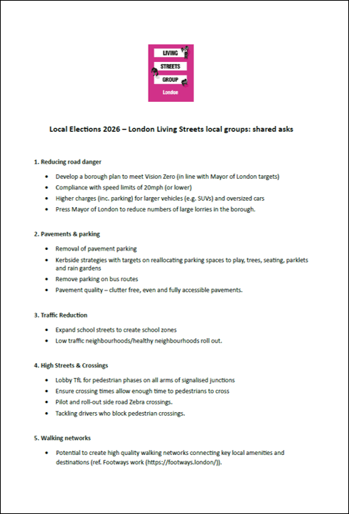
If you are campaigning for safer and more attractive streets in the London borough that you live or work in, London Living Streets has put together a set of asks that you might wish to discuss with local parties and candidates. The asks cover 5 main areas:
1. Reducing road danger
2. Pavements & parking
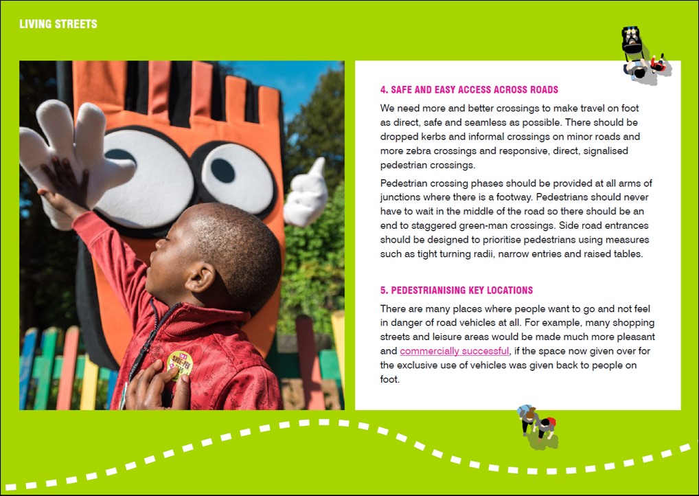
3. Motor Vehicle Traffic Reduction
4. High Streets & Crossings
5. Walking networks
These aim to be areas that each borough can control so issues such as improving walking across Central London have not been included. They are all summarised on one page; please download them here
We hope that this is of help and please do get in touch if we can be of any help in your borough.
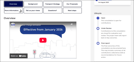
Transport for London (TfL) is proposing a number of changes to its Central London Congestion Charging Zone. Some of these are good; others could go further.
London Living Streets’ response is as follows if you would like to use any of these ideas in your submissions:
1. Proposal A: Increasing the Congestion Charge from £15 to £18
London Living Streets supports this proposal. However, we propose that the increase matches the rate of increase in inflation since 2020 (when the charge was last increased) and that the new level should be set at that level rather than the below inflation rise to £18 that is proposed.
2. Proposal B: Changes to create a new Cleaner Vehicle Discount. We propose that there is an annual review of the numbers of discounted vehicles that are entering the Congestion Charging Zone (CCZ) to ensure that the discounted rates are reassessed if the increase in vehicles of this type entering the CCZ is higher than projected. We support TfL’s assertion that any motor vehicle adds to “increased traffic and congestion in the CCZ” and in particular is a source of danger and intimidation to people who are walking, wheeling and cycling; the impact of their use should be monitored closely.
3. Proposal C: Changes to the Residents’ Discount for new applicants. We do not support these proposals. With the exception of residents with a disability, the 90% discount is excessive and should be reduced significantly between now and 2030. In general, the public transport options within the CCZ are exceptional and far greater disincentives should be applied to discourage motor vehicle use whether by residents or other users of the CCZ. Over time it should be intended to reduce the discount for residents towards zero.
Other Comments.
a) We strongly support the proposal to move to incremental annual increases to the Congestion Charge as with public passenger transport fares.
b) More generally we believe that to reduce road danger in Central London (where a disproportionate number of road casualties occur), congestion charging should once again be applied in the evening every day of the week. It is against the aims of the MTS and Healthy Streets that people driving motor vehicles should be in effect subsidised to drive into the CCZ at the time of the day when many of the streets of central London are at their busiest and most congested for people walking. The evening charging should be applied up to 11pm.
c) Again, more generally, the pricing of driving in London is not working and TfL/GLA should consider both the introduction of a Zero Emission Zone within the CCZ and also consider the introduction of pay-per-mile charging for driving motor vehicles throughout London. This is needed for many reasons not least of which is how far London is away from its 2030 Vision Zero target. Evidence is increasing as to the impact that traffic volume reduction has on road casualties and more effective measures are needed to reduce traffic volumes across the capital. There is a pressing need to reduce traffic on main roads across London in part to support improved bus journey times.
d) There are opportunities through the Congestion Charge to discourage the use of SUV which tend to increase the congestion owing to their larger size and, as recent research has found, increase road danger especially to people walking. An increased charge should be levied for SUVs.
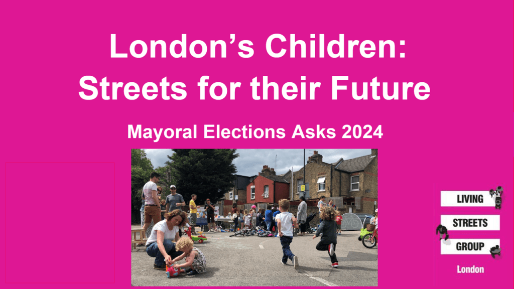
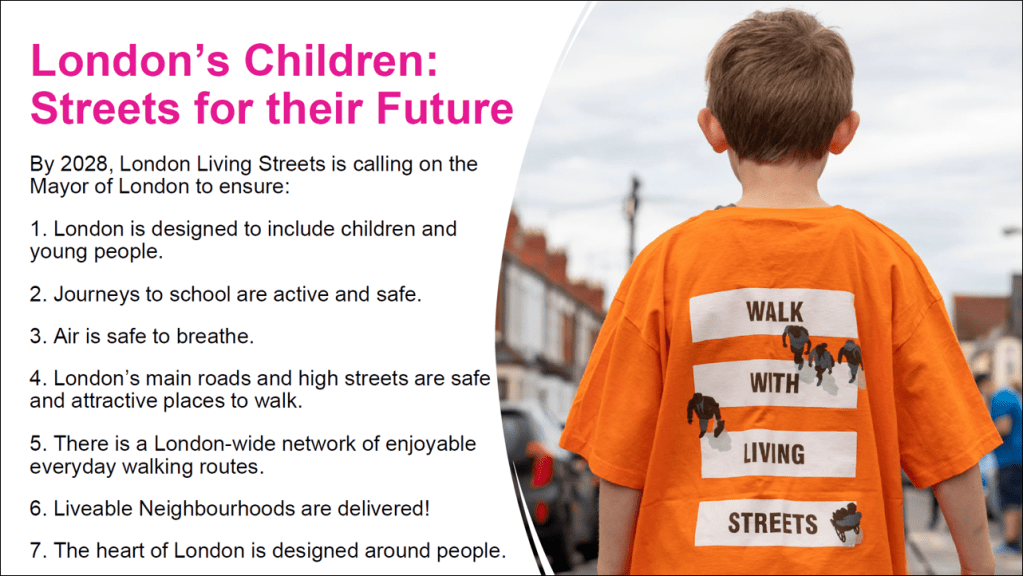
“Children are a kind of indicator species. If we can build a successful city for children, we will have a successful city for all people.”Mayor Enrique Peñalosa of Bogotá
The poor quality of the streets and roads that we have created over the past one hundred years across the UK has harmed many people and groups but perhaps none more so than children and young people. The examples of this are numerous but include:
2. The danger to children from our roads – 10 young children (aged seven or under) are killed or seriously injured on British roads every week.
3. High levels of childhood obesity and low levels of activity by children – just 23% of boys and 20% of girls meet the national recommended level of activity.
There are of course many reasons for this but we wanted to focus on the role that our streets and public spaces play. Improving them can play a vital role in helping children to lead healthier, happier and safer lives. In our manifesto for the 2024 London Mayoral and Assembly elections (2nd May 2024), we have put together some ideas as to how to tackle these issues.
Our focus is on making changes to our streets so that they work for our children and young people. Key themes include involving children and young people in street design and decisions about the places they live in, delivering air that is safe to breathe across London, creating journeys to school that are active and safe along with streets and roads work for all of us and especially in the streets where people live, in our town centres and high streets and in the heart of the city that many of us want to visit.
We hope that these ideas will be of value in discussions with Mayoral and Assembly member candidates alike and we look forward to seeing these ideas being included in the policies and approaches of the next and future Mayoral administrations.
London Living Streets has been campaigning for improved pedestrian crossings for some time. In 2017, TfL undertook to carry out regular ‘active travel’ reviews of every crossing, with the aim of reducing ‘wait’ times for pedestrians, cyclists and bus passengers. Since then, TfL have reviewed well over 2,000 sites including over 200 put forward by our supporters as having particularly excessive pedestrian wait times. The pace of work slowed down during the Covid lockdowns but the review programme is now back on track.
There are still a large number of traffic lights in London that have no pedestrian phase at all. Ahead of the 2021 London Mayoral elections, Sadiq Khan pledged to review such sites and install pedestrian ‘green person’ lights where they are needed. That review process is now also underway and a number of sites are being selected for action over the coming year.
Even though much progress has been made, there is still more to do. This year we’re asking people to let us know of traffic lights that have pedestrian signals on some, but not all, arms of the junction. (As noted above, junctions with no pedestrian arms at all are already being considered in TfL’s programme). This is a great opportunity to ensure that junctions that are missing some – but not all – pedestrian signals are included in the review process.
If you know of any sites where some arms have missing pedestrian signals, making it difficult to cross, please tell us by emailing the location along with a short description of the problem (e.g. Merton Road at its junction with Kimber Road SW18), missing pedestrian lights on northern arm crossing Merton Road) to: londoncrossings@gmail.com
Please submit locations by 1st March 2023, in order for TfL to be able to consider them for their 2023/24 programme of work.
We’ll collate the data, highlight those sites that seem most problematic and forward them to TfL for consideration as part of the pedestrian signals improvement programme.
Missing pedestrian crossing on the junction of Borough High Street and Marshalsea Road and Great Dover Street in SE1
This Thursday’s (17th November) GLA Assembly meeting at City Hall sees an important discussion and vote that will help shape the future of transport in London and could have huge benefits for pedestrians in London in the medium and longer term. In the light of the challenges of toxic air pollution, the climate emergency and traffic congestion, the Mayor of London is proposing a revision to the Mayor’s Transport Strategy as follows:
Proposal 24.1: The Mayor, through TfL and the boroughs, will seek to address the triple challenges of toxic air pollution, the climate emergency and traffic congestion through road user charging schemes including by expanding the Ultra Low Emission Zone London-wide.
London Living Streets believes that this proposal will not only help tackle these three challenges but that it is essential for the Mayor to be able to achieve his target of a 27% fall in traffic volumes (from a 2018 base) by 2030.
Adopting this proposal will have real benefits for people on foot as an expanded ULEZ helps tackle the London’s air pollution crisis and makes walking safer and a more attractive choice. In the longer term, road user charging can help transform London from the point of view of those on foot offering the space to create streets for people and reducing the numbers of pedestrians who are killed and injured on our roads.
Ahead of the debate and Q&A with the Mayor of London and the Deputy Mayor for Transport on 17th November, London Living Streets has written to every Assembly Member urging them to support the proposal.
If you are keen to get involved in the local elections that are coming up on 5th May, London Living Streets has put together a vision that sets out how the Councillors that are elected can help make the borough they live in and London overall a great place to walk.
We are asking candidates to embrace policies that enable people to walk by improving the opportunities and experience for all abilities and ages to use our streets without fear of vehicle danger. Please do discuss these issues with Councillor candidates and let us know who is up for this kind of change.
The Vision is based around 5 main themes:
1. Clear footways.
2. Reducing the dominance and volumes of motor traffic on our streets.
If you could take a few minutes to repond to the survey before the deadline of 6th October perhaps including some or all of the following that would be really appreciated
London Living Streets supports:
1. The retention of the increase in the charge to £15 and the removal of Autopay discount. We wish to see mechanisms for future regular increases in the charge at above inflation levels with the potential to link the CCZ charge to the achievement of the traffic reduction targets set out in the Mayor’s Transport Strategy.
2. The principle of charging at the weekend.
Overall we believe that if the Mayor wants people to come into the CCZ area to socialise at weekends and evenings, it makes no sense to encourage people to drive in thus creating an unpleasant, polluted and unsafe street environment at the same time that many who have arrived by public transport and active forms of travel are using the streets (as part of the night-time economy). Enabling driving into this part of central London will have the effect of making London more dangerous for people walking and cycling, because of increased traffic volumes. It is vital that we remember that across the Inner London boroughs almost two-thirds of households do not have access to a motor vehicle. While we need to enable access for those who are disabled, in the light of the MTS targets and now the climate emergency, the priority is to support those who make use of active forms of travel (walking, cycling and public transport). To be enabling driven journeys in this way is contrary to transport policy in London.
London Living Streets recommends:
1. That owing to the numbers of people walking, cycling and using public transport in the evenings, that the charge should continue until 10pm on all seven days of the week and that the charging period at weekends should begin at 7am. Overall we believe that ending the charge at 6pm will be a retrograde step that will reduce London’s efforts to a) improve air quality, b) reduce CO2 emissions and c) meet Vision Zero obligations. A specific analysis of the impact of the earlier end to charging should appear in the impact assessment.
2. That the discount for residents is excessive and should be reduced significantly.
3. That a far wider principle of charging for motor vehicles using London’s roads is needed and that for many reasons (inc reducing road danger, improving air quality and reducing CO2 emissions) London needs to move on very quickly to a London-wide universal smart road pricing system (potentially as set out by the Centre for London in 2019 in its report https://www.centreforlondon.org/publication/road-user-charging/)
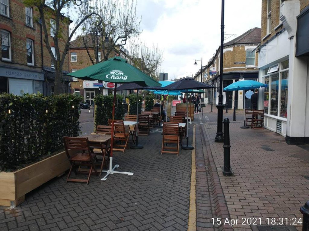
Here is something you may have seen, but never heard of – al fresco streets! And you won’t have heard of them because the term has only just been invented by some enterprising officers at Wandsworth Council. In fact, this Council may be in the forefront of a move to transform some London streets in wholly unexpected ways.
The basic idea is to turn suitable streets into places where people on foot really are top dog. Motor traffic is largely or completely excluded and all parking suspended. This happens either at weekends or every day. In summer, and perhaps all year round. The al fresco street takes off from the already hugely popular ‘streateries’ (the name given to what has been done in Soho) that have caught on all over the country with restaurants during the Covid epidemic[i] — the difference being a ‘whole street’ treatment (individual businesses do not have to apply for permission to spread across the road) and the exclusion of motor traffic.
It was the Covid pandemic that kicked off these ideas. Lockdown rules (a constantly changing kaleidoscope, of course) ordered almost all retail outlets, pubs, wine bars, restaurants, coffee shops etc to close. And when they could eventually open, social distancing initially said patrons must stay outside. In early summer last year, Wandsworth Council identified two streets with a concentration of such businesses, and introduced the al fresco experiment. One was Northcote Road in Battersea, SW11, already a very popular shopping and eating out street. The other was Old York Road in Central Wandsworth, SW18. And most recently, a third street, part of Bedford Hill in Balham, SW12 is trialling a similar, temporary makeover. All three, during their operational times, are closed to delivery lorries, cars and other motor vehicles. Businesses are allowed to spread out seating and tables across the pavement and on to much of the carriageway, with the strict requirement that a wide passageway is left along the carriageway for pedestrians, disabled people and their mobility vehicles, and cyclists. In Northcote Road this happens at weekends only; in Old York Road, every day. Local circumstances, flexibility, experimentation are the name of the game in terms of what physical measures, traffic orders etc are introduced. And throughout, it is important that Officers considered the needs of disabled people, including ease of access and installation of dropped kerbs where these are missing.
Transport for London (TfL) had to re-reroute buses, now for the second year running. The Met was asked to review, and agreed, that adequate measures had been put in place to deter a terrorist attack. Businesses were brought on board. The pubs and wine-bars on Northcote Road agreed a community toilet scheme where everyone could use their facilities even if not drinking or eating at the particular establishment. Money was found for planters, water-filled barriers, even concrete caissons at certain locations. Traffic orders were drawn up to minimise inconvenience to residents on side roads needing to use their cars. None of this was easy.
We are now in the 2nd year of this experiment. It has proved immensely popular, not only with local people, but other Londoners from further afield. All day Saturday and Sunday, Northcote Road is awash with throngs of people, including many families. Eating and drinking establishments are obviously doing very well. Retail shopkeepers, particularly clothes shops on Northcote Road, had been very hesitant originally, but most are now seeing upturns in their turnover. And in the few weeks the Bedford Hill experiment has been going, local businesses and residents living on that stretch of the road are welcoming it with enthusiasm. One group there however, called One Wandsworth that was started last year in reaction to Low Traffic Neighbourhoods in Tooting, has filled the airwaves with a host of objections, often virulently worded, allegedly in the name of residents – to the removal of some parking.
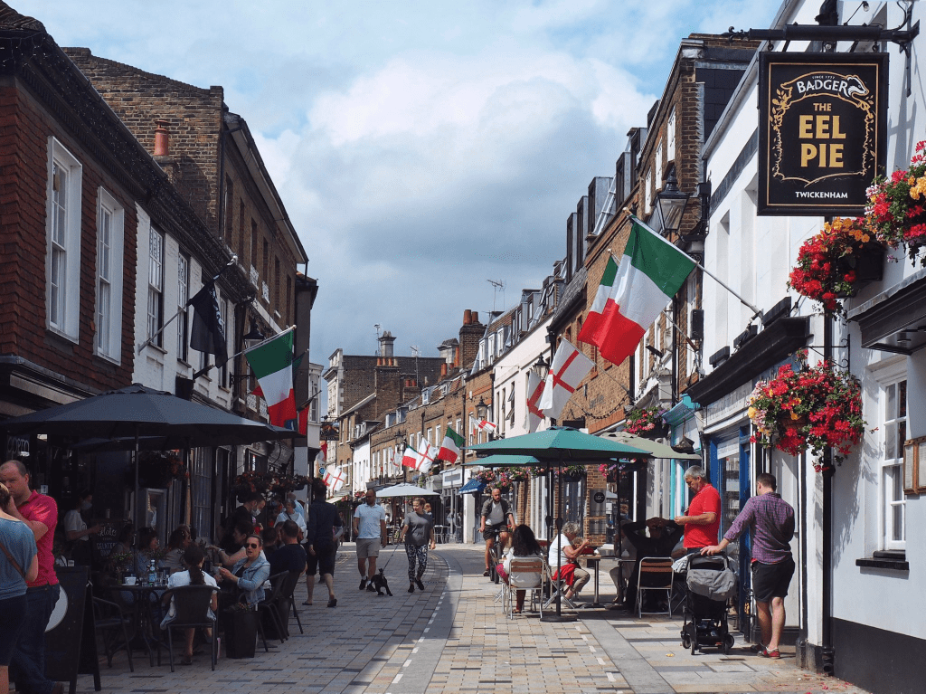
There are examples of these al fresco streets elsewhere. A short stretch of Kensington Park Road in Notting Hill, W11. And, most delightful of all, Church Street in Twickenham which lies a stone’s throw from the Thames opposite Eel Pie Island.
Have you got any al fresco street in your part of London with a similar experiment in hand? And if so, do let us know (if possible sending a pic too), as well as what you think of it, and how it might be improved.
And if you haven’t, can you suggest a possible candidate street in your borough where your Council could try out the idea next summer? Do talk to your Ward Councillors and/or appropriate Council Officers and suggest they look into the idea.
Church Street Twickenham (LB Richmond) (Photo: Shona Lyons, Crusader Travel)
And would you like a guided tour of one of Wandsworth’s al fresco streets? WANDSWORTH LIVING STREETS would be happy to show you around. And talk through the difficulties that can arise and how they can be overcome. We can also put your Borough Officers in touch with the relevant Officers in Wandsworth (and the Councillor responsible for the project) if they would like to learn more. Contact Robert Molteno, Secretary, Wandsworth Living Streets at Robert.Molteno@gmail.com
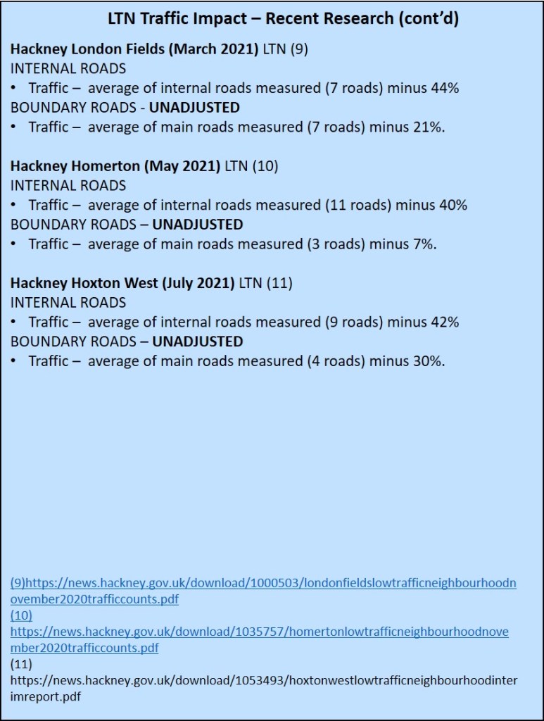
It has now been just over a year since the first Low Traffic Neighbourhoods were introduced in London in response to the first lockdown and initial monitoring results are in from 4 of the London boroughs that introduced them at that time – Islington, Hackney, Lambeth and Southwark.
We thought that it might be helpful to summarise what the results have been so far. If we have missed anything (highly likely!) then please do get in touch and we will amend and add to these findings.
There are a couple of things to note before we get to the results. Firstly, with the exception of Hackney, all of the final results have been adjusted (normalised) to take into account the changes that were occurring in traffic volumes (owing to the pandemic) across the borough/London at the time that the post-implementation monitoring took place. So hopefully like is being compared with like. In Hackney, the council has given other data to allow comparison but has not adjusted the figures.
Secondly, cycling numbers do appear to increase dramatically when LTNs are introduced. The exception seems to be in Islington but that appears to be because the pre-implementation research was done during summer 2020 and the post-implementation work was done in November 2020 and February 2021 when overall cycling numbers are likely to be far lower.
Thirdly, we have always thought from previous research in the Mini-Holland boroughs (Waltham Forest, Enfield and Kingston) that the big winners when LTNs are introduced are people on foot[1][2] but unfortunately none of the data released so far captures the impact on walking. The available data to date therefore probably understates the active travel benefits of the new cohort of LTNs in London.
All of the raw data from the monitoring reports can be downloaded here. This spreadsheet has links to all of the Council monitoring reports.
So what have the results shown so far?
1. Motor traffic volumes.
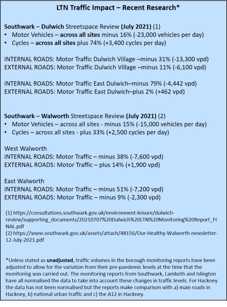
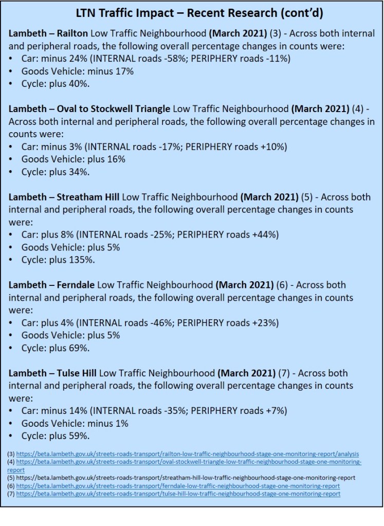
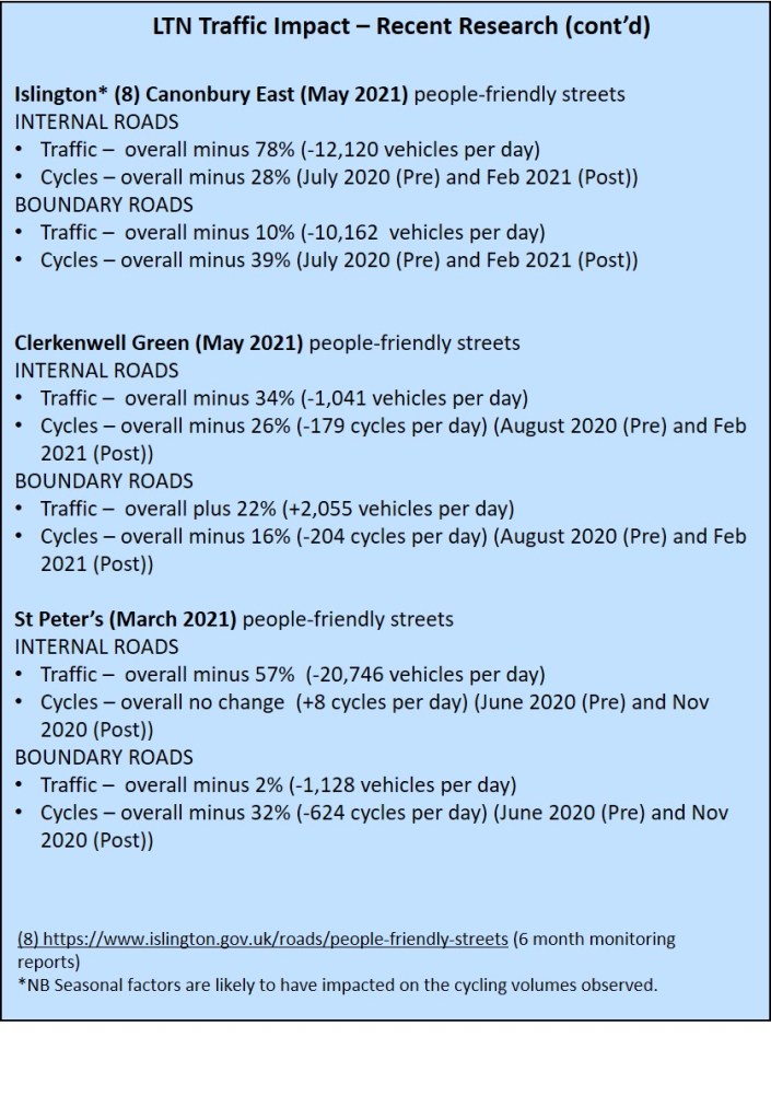
All Roads. While there are exceptions, the trend is one of a reduction in overall traffic volumes (across the roads that are both internal and external/peripheral to the LTN) with an average decline of 8.6% in total traffic volumes across the 7 studies (5 Lambeth and 2 Southwark) where estimates are given of this measure.
Roads INSIDE the LTNs. There are 15 studies where we can assess the impact of the LTN on the volumes of traffic inside the LTN. There is an average decline of 45% in motor traffic volumes across the 15 studies with a maximum decline of 79% and a minimum fall of 17%.
Roads OUTSIDE the LTN. On average, across 15 studies[1] traffic volumes on external/peripheral roads have increased by 4.5% with a maximum decline of 17% and a maximum increase of 44%. Across the 15 studies, there was a decline in traffic volumes on these roads in 7 studies and an increase in 8 studies.
2. Cycling.
All roads. Total cycling volumes were measured in 7 studies (Lambeth and Southwark). All studies saw an increase in cycling volumes with the average across the studies being a 63% increase in cycling (the range was maximum +135% and the minimum was +33%).
As noted earlier, the data for the internal and external roads is thrown by the dates of the Islington research but in Lambeth cycling on roads inside the LTNs averaged a 68% increase and on the periphery roads an increase of 62%.
Summary. So although these studies were often the first in a series of monitoring, is it reasonable to suggest the following?
There is solid evidence to suggest that on the roads inside an LTN motor traffic volumes are likely to fall by up to a half.
There is evidence to indicate that traffic evaporation is likely to occur when an LTN is introduced and that depending on the design and location of the scheme overall traffic volumes (inside and outside the LTN) will decline by more than 5%.
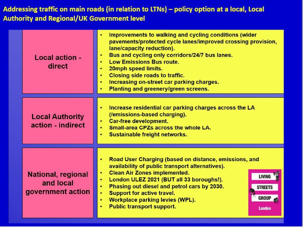
Again, depending on the design and location of the LTN, traffic on external/periphery roads may rise by up to 5% and that when LTNs are developed, complementary measures should also be delivered that work to reduce traffic on nearby main/boundary roads. London Living Streets has developed a checklist for what should be considered and this is summarised in the chart below.
Detailed Results. The detailed results are shown in the jpegs below and are brought together here.
[1] Making use of the data from Hackney as shown in the spreadsheet.
The hope is that, as we emerge from the pandemic, our high streets will return to the bustling places they were. But beneath the bustle an intense competition is taking place for access and space: walking, shopping, eating and drinking, parking, loading, sitting etc.
We’re deliberately seeking two distinct perspectives on this issue in order to illuminate it:
Mário Alves is Secretary-General of the International Federation of Pedestrians and a long-time advocate of providing good facilities for walkers. Mário will draw on work he’s doing as part of the Horizon-2020 MORE project as well as his broader experience.
John Crosk has been involved with Brewery Distribution for over 40 years. These days he is Vice Chairman of The Brewery Logistics Group (responsible for over 75% of London beer deliveries) and manages the Central London Freight Quality Partnership, which brings together London boroughs and freight operators.
Between them, our speakers know a lot about the subject under discussion and we look forward to a stimulating discussion, perhaps even a bit of a debate? Walking@Tea-Time is a joint initiative ofLondon Living Streets and the Active Travel Academy at University of Westminster